


Before the iconic bridge, there was another way across the New River Gorge. You can drive it on Google Street View.

As the first Bridge Day festival since the creation of the New River Gorge National Park and Preserve, this October 16 would have been the biggest Bridge Day ever.
Unfortunately, the festival was cancelled this year to preserve hospital capacity during the pandemic. But even if you’re not going down to Fayette County this weekend to watch BASE jumpers and ogle the scenery, you can have a private five-minute celebration of the magnificent structure by driving the route that people had to drive to cross the gorge before the bridge opened in 1977—on Google Street View.


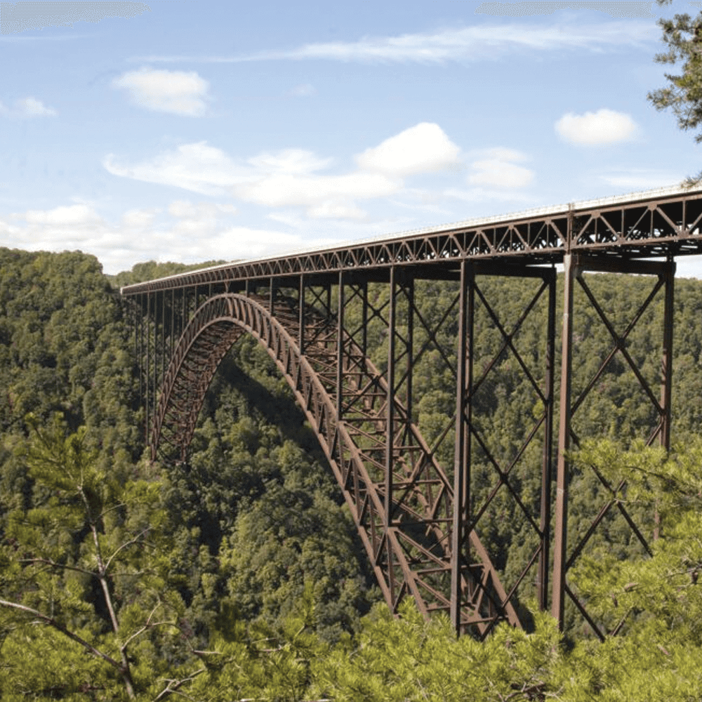
At U.S. Route 19, the New River Gorge is nearly 900 feet deep and more than half a mile wide. The first road to cross the gorge at that point was built in 1909 and came to be called Fayette Station Road. In the mid-century decades, drivers shared the narrow, switchbacky two-lane down one side of the gorge and up the other with coal and log trucks—a harrowing, though beautiful, journey of half an hour rim to rim.
The creation in the 1970s of Corridor L, U.S. 19, between I-79 near Sutton and I-77 at Beckley as part of the Appalachian Development Highway System called for a better path across the gorge. It took three years to build the new bridge and, when it opened in 1977, it was as all West Virginians know the longest single-arch bridge in the world—a distinction it maintained until 2003. It’s still the prettiest. Just sayin’.
The new bridge cut the crossing time from 30 minutes to 30 seconds. And it transformed the Fayette Station Road crossing: By removing the huge hurry-up trucks, it made the journey far less precarious. And by the simple fact of dominating the landscape as a world-renowned engineering marvel of stunning beauty, it enhanced the old route with an unparalleled backdrop.


You can drive it rim to rim in just a few minutes on Google Street View. Start here—or read below for more detailed instructions.
Clicking through the entire distance along the straightaways and around the hairpin turns gives you a real sense of the length and treacherousness of the trip—imagine it in a storm or at night, with overloaded trucks bearing down and your kids in the back seat. You’ll catch glimpses of the river and the New River Gorge Bridge through the foliage. You can also just click on the old Fayette Station Bridge to see its replacement tower over it from an angle like no other.
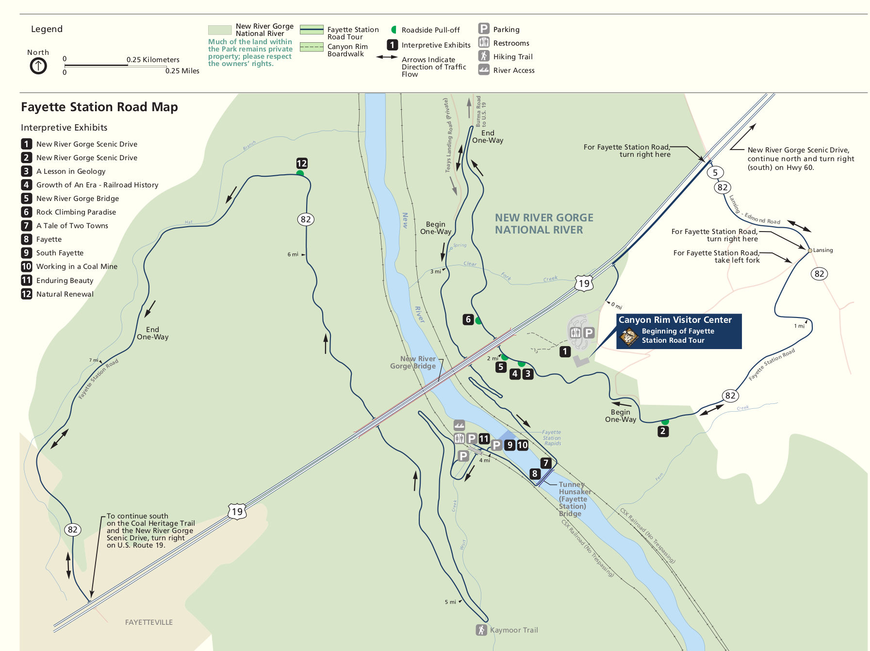
The Street View–adventurous can have a more media-rich experience by coordinating with the National Park Service’s Fayette Station Road Audio Tour and, for a little more help, a related map. Street View becomes available at about the point labelled “2” on the Park Service map. The audio tour reviews the natural, mining, and railroad history of the route, especially of the mining towns of Fayette and South Fayette that bustled at either end of the old bridge a century ago, now gone nearly without a trace.

A virtual drive is not the exhilaration of Bridge Day, but look at it this way: You get to miss the crowds, and you’ll have an even greater appreciation of the bridge when you go to Bridge Day next year.
Detailed instructions for driving Street View
- Start here, or search maps.google.com for “Canyon Rim Visitor Center” and click on the Street View “pegman” in the lower right.
- Choose a spot on the winding blue route that crosses the river, strap in, and click.
- Navigating:
- Use the window in the lower left to be sure your pegman is oriented in the direction you want to go. Drag the image left or right to change orientation.
- Click on the road ahead of you to advance.
READ MORE ARTICLES FROM MORGANTOWN LOWDOWN